|
 |
|
主動式GPS天線 |
|
|
|
 |
Introduction for
GPS History and Application
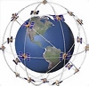
The Global Positioning System
(GPS) is currently the only fully functional Global
Navigation Satellite System (GNSS). Utilizing a
constellation of at least 24 medium Earth orbit satellites
that transmit precise microwave signals, the system enables
a GPS receiver to determine its location,
speed and direction. |
|
Developed by the United States
Department of Defense, it is officially named NAVSTAR GPS
(Contrary to popular belief, NAVSTAR is not an acronym for NAVigation Satellite Timing And Ranging, but simply a name
given by Mr. John Walsh, a key decision maker when it came
to the budget for the GPS program). The satellite
constellation is managed by the United States Air Force 50th
Space Wing. The cost of maintaining the system is approximately US$750 million per
year, including the replacement of aging satellites, and
research and development. Despite this fact, GPS is free for
civilian use as a public good. |
|
|
|
    |
|
|
|
GPS has become a widely used aid
to navigation worldwide, and a useful tool for map-making,
land surveying, commerce, and scientific uses. GPS also
provides a precise time reference used in many applications
including scientific study of earthquakes, and
synchronization of telecommunications networks. |
|
|
|